


Assessment of Karaburun Passenger Port Construction
Underwater Research Society – Mediterranean Monk Seal Group (SAD-AFAG) is assigned on the date of October 15th 2009 by the Ministry of Environment and Forestry to give opinion about possible environmental effects of the port construction project which will be executed by DLH İzmir Transportation Regional Directorate in Karaburun Arslan Cape, Mimoza Bay.
SAD-AFAG is improving its knowledge and experiences on “Coastal and Marine Areas Management and Planning” and increasing its capacity as being an organization executing international projects in corporation with scientists and related Ministries in this context. Karaburun Peninsula is highly recognized by SAD-AFAG whereby ongoing monitoring and research studies carrying on about Mediterranean Monk Seal and coastal and marine areas since 1991. Additionally scientific experts of the group took active role on the field studies and documentation works in “Mediterranean Monk Seal Monitoring and Conservation in Karaburun Peninsula Project” in the final half of 2009. In consideration of these actual and distinctive background information, the group considered to bring its opinions about environmental effects of the port together with possible socio-cultural, economic effects and coastal-marine security to the attention of the authorities and evaluated its convenience under the date of November 3th 2009.
The port project to be constructed in Arslanburnu will be comprised of 220 m. long dock, 80 m. long – 10 m. width landing-stage and 51 m. long additional dock. Two 20 m. long slopes will be constructed on the edges of the adjacent dock to ensure passengers and vehicles evacuation from ships. Landing-stage will be formed by bored pile system and back stage and dock will be constructed by sealant and side-piles. Ships with the capacity of 20 vehicles and 250 passengers will cruise on the route between İzmir Konak – Foça – Mordoğan – Karaburun. Dredging won’t be performed due to the convenience of the ground for the construction and don’t hold any characteristics of liquidization. Land filling area will be approximately 9. 500 m2 and water depth is around 0-6 meters in the area. It’s seen that 5 meters fill height will be enough as result of addition average 3 meters water depth and +2 meters dock height above sea level. According these values, it’s calculated that 47.500 m3 coastal fill will be done at the end of the project.
Our conviction on the advantages to be gained in context of the development of Karaburun by means of the investments oriented to seafaring are indicated clearly in the report and brought to the attention of official authorities. In case of the port construction come to realize, the species under protection with national and international regulations under negative interaction with the port and the species classified as endangered species according to IUCN citerias such as Mediterranean Monk Seal (Monachus monachus) and Sea grasses (Posidonia oceanica) will come into prominence. Claimed interactions, solid proofs and references are brought to the attention of official authorities as well.
The restoration and structural revision of Saipaltı Port pointed out within the report to solidify our organizational goodwill and fair positive view on seafaring in this context. It’s determined that this alternative solution will have fewer effects on the Mediterranean Monk Seals and Sea grasses and will have social and economic contributions to the region as well. The efforts and actions are continuing toward the construction of the port in Arslan Cape in contrast to its conserved environment and despite all of the scientific data and alternative solutions suggested. Additionally some unconfirmed information received about the efforts to acquit port from the context of EIA (Environmental Impact Assessment).
We have an intent motivation in monitoring this process with deep concern and take legal actions if it’s required. We observe the plastic deformation of the clean and pristine costs as a disaster as a result of wrong planning decisions and finally eliminate main reasons of the people to visit these exceptional costs such as Karaburun. We believe that the restoration of Saipaltı Port with fewer costs and fewer natural destruction will create homogeneity in the development of local economy and will highly match up with the principle of mindfully consumption of the national resources. SAD-AFAG is currently completing its preliminary studies to apply to court in case construction preparation starts .
You may contact with SAD in order to get further information on the issue.

Animation of the port planning to be constructed on Arslan Cape. (Drawn as an outline, not a technical drawing)

Healthy posidonia grasses (Posidonia oceanica) in and around Arslan Cape in Karaburun.

The coastline and beach in Karaburun Mimoza Bay, which is currently open to the public use.
Karaburun Peninsula Mediterranean Monk Seal Monitoring and Protection Project Completed
Karaburun Peninsula Mediterranean Monk Seal (Monachus monachus) Monitoring and Protection Project, contracted by Ministry of Environment and Forestry İzmir Provincial Environment and Forestry Directorate, completed under expertise of SAD-AFAG.
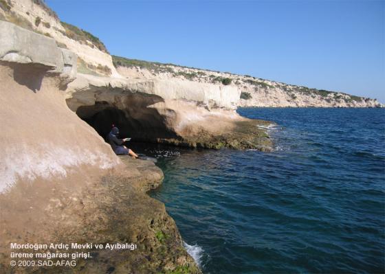
Issues are categorized in the aspects of human activities threatening coastal and marine areas, fishery, environmental pollution, tourism, coastal construction, human entrances to Mediterranean Monk Seal caves in Karaburun Peninsula which is one of the least degenerated coastal areas in Aegean Region and these problems are studied in detail.
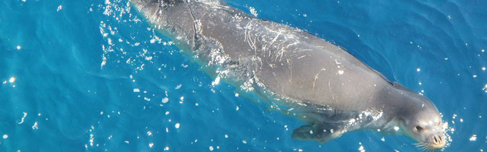
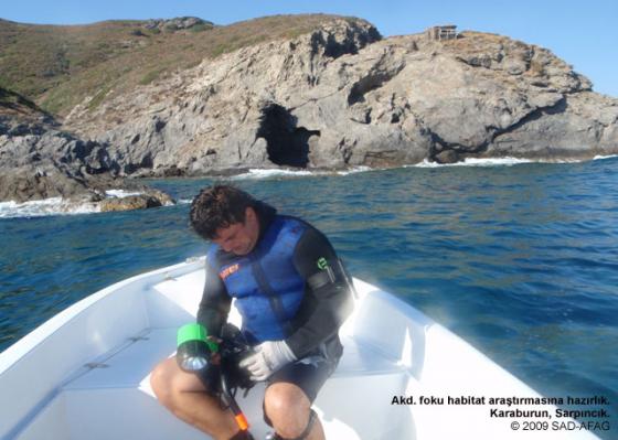
SAD-AFAG took place in the project with 8 people and acquired data provided by up-to-date and distinctive field studies and intelligence studies by this team. Observed changes in Karaburun are compared with the data acquired in 1991. It’s identified and documented in the conducted studies that approximately five Mediterranean Monk Seal currently using area and this number can increase to seven.
The leading factor threatening area is defined as unplanned and dense urbanization (cooperatives) destructing characteristic coastal structure within Mordoğan and Karaburun municipality boundaries. Outlawed summer house constructions within first degree protected area in Hamzabükü, outlawed individual construction (summer houses) examples in the west side of the peninsula and dense and adjacent urbanization which is causing breakages in pristine coasts, destructing cultivated areas and violating geographical natural beauty are determined. Additionally excessive and illegal fishery examples are determined throughout the peninsula and it can also be summarized as one of the main problems threatening the area. Examples such as fishing with fish spear at night, fishing with diving tube and fishing spear, illegal troll and coastal dragging, amateur fishermen using professional techniques are also seen within the area.
The coastal zones of the peninsula is protecting under “protected area” statue. However summer house cooperatives beginning from the end point of first degree protected areas designating possible irreversible change for the area. For the purpose of olive cultivation, dense agricultural activities converting peninsula’s characteristic flora, ecology and cultural values are also appointed.
Karaburun Peninsula’s pristine coasts and habitats (caves) sheltering Mediterranean Monk Seal keep have essential importance for the nourishment, sheltering and breeding of this specie. The need of the integrated marine and coastal areas management model is evaluated for the purpose of determining utilization-protection balance of this longest natural coastal area of the Aegean Region within this project.
Gökova ICMM Project “Farmer Stakeholders Meeting” Completed

Stakeholders Problem Analysis Meetings” will be held on 5th – 8th December 2009 in Gökova, Akyaka District as project area within Gökova Special Environmental Protection Area Integrated Marine and Coastal Management Planning Project carrying on by BBI Matra foundation and SAD-AFAG in corporation with EPASA, MARA, Eurosite, Rubicon.
“Stakeholders Problem Analysis Meetings” within Gökova SEPA Integrated Marine and Coastal Management Planning Project are completed on 8th December 2009 Tuesday with “Farmers Stakeholders Meeting” as fourth assembly.
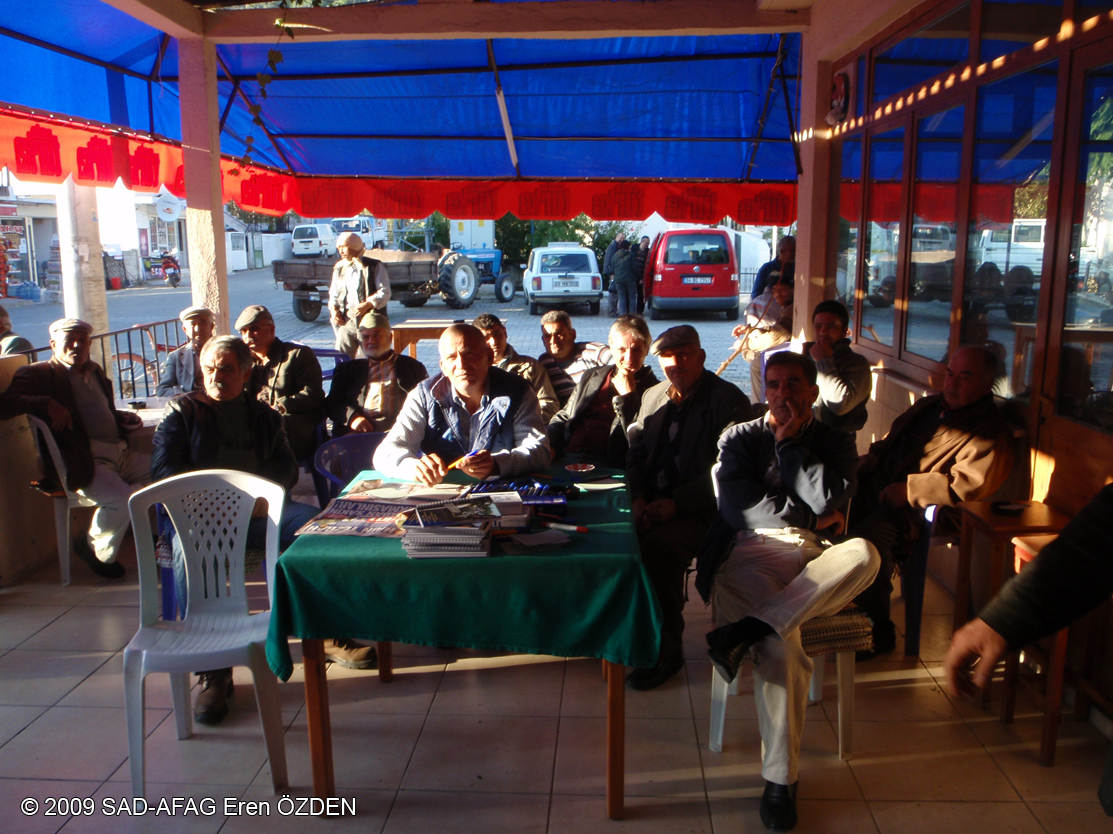
Mr. Ayhan Toprak (MoEF, EPASA, Muğla Directorate), local farmers, Gökova Akyaka Lovers Association Headman, former municipality parliament members, Gökova Farmers Cooperative Headman and SAD-AFAG project team is contributed to the meeting. Meeting is coordinated by Bahar Suseven and SAD-AFAG Gökova Project Manager N. Ozan Veryeri and Project Assistant Eren Özden.
“Gökova Stakeholders Problem Analysis Meeting” is implemented together with 21 personal or representative participants from different relevant stakeholder groups related in utilization and/or constitution of Gökova Integrated Marine and Coastal Management Planning. In the invitation and participation of sectoral representatives, it is considered to represent different parts of the project area covering whole Gökova SEPA Area.
After welcoming speech of Project Manager N. Ozan Veryeri, project introductory information is shared with the participants and Project Informal Document is distributed. Contextual and implementative differences between previous projects conducted on the region and current Gökova Integrated Marine and Coastal Management Planning Project are explained to the participants. Meeting content and problem tree technique as the used methodology are explained to the participants. Problems within “Agriculture” sector in SEPA Area are equally and impartially collected from participants with the designated method. In problem analysis part of the meeting, collected problems are placed on the board anontmously, grouped according their connection and problem analysis diagram took its final version after all participants expressed their opinions and comments on the pinned issues.
At the end of the meeting, general problems of the local “Farmers and Agriculturists” are seen on the sticky board by all of the participants, project partners and project team.
Project Stakeholder Problem Analysis Meetings are completed with “Farmers and Agriculturists” stakeholders group assembly on 8 December 2009 in Gökova, Center.
Gökova ICMM Project “Tourism Stakeholders Meeting” Completed
Stakeholders Problem Analysis Meetings” will be held on 5th – 8th December 2009 in Gökova, Akyaka District as project area within Gökova Special Environmental Protection Area Integrated Marine and Coastal Management Planning Project carrying on by BBI Matra foundation and SAD-AFAG in corporation with EPASA, MARA, Eurosite, Rubicon.
“Stakeholders Problem Analysis Meetings” within Gökova SEPA Integrated Marine and Coastal Management Planning Project are continuing on 7th December 2009 Monday with “Tourism Stakeholders Group Meeting” as third assembly.
Mr. Ayhan Toprak (MoEF, EPASA, Muğla Directorate) Ahmet Çalca (Akyaka Mayor), Serdar Denktaş (Akyaka City Council President) Akyaka Village Headman, hotel keepers from Akyaka, pension keepers from Akbük, local press and SAD-AFAG sectoral specialists participated in the meeting. Tourism Meeting is coordinated by Sezer Göktan and SAD-AFAG Gökova Project Manager N. Ozan Veryeri and Project Assistant Eren Özden.
“Gökova Stakeholders Problem Analysis Meeting” is implemented together with 13 personal or representative participants from different relevant stakeholder groups related in utilization and/or constitution of Gökova Integrated Marine and Coastal Management Planning. In the invitation and participation of sectoral representatives, it is considered to represent different parts of the project area covering whole Gökova SEPA Area.
After welcoming speech of Project Manager N. Ozan Veryeri, project introductory information is shared with the participants and Project Informal Document is distributed. Contextual and implementation differences between previous implemented projects on the region and current Gökova Integrated Marine and Coastal Management Planning Project are explained to the participants. Content of the meeting and problem tree technique as the methodology to be used are explained to the participants. Problems within “Tourism” sector in SEPA Area are equally and impartially collected from participants with the designated method. In problem analysis part of the meeting, collected problems are placed on the board anonymously , grouped according their connection and problem analysis diagram took its final version after all participants expressed their opinions and comments on the pinned issues.
At the end of the meeting three general problems are seen at the center of the mentioned issues by Gökova Tourism Stakeholders Group. These problems can be listed as; Pollution, Administrative Problems and Socio-Cultural Communication Problems.
Project Stakeholder Problem Analysis Meetings will continue with “Farmers and Agriculturists” stakeholder group assembly on 8 December 2009 at 14:00 -17:00 in Gökova, Center.


